
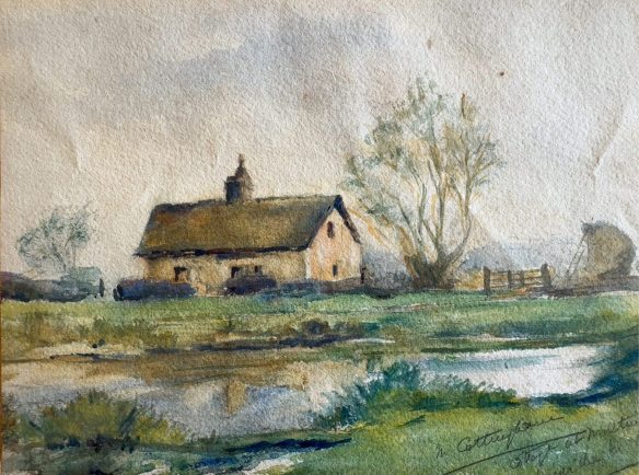
This view of the house later known as ‘Fishers’ across the pond on Malting Green and onto what later became known as ‘Potash Field’ beyond was painted by Mrs Mary B. Cottingham, a local painter and member of the Parish Council, in the 1920s.
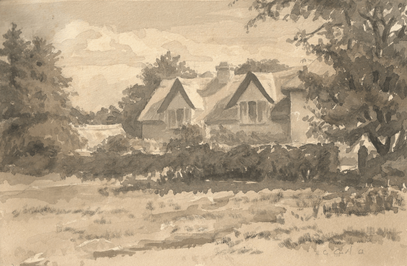
An image of the changed house from the same viewpoint in the 1950s, artist unknown
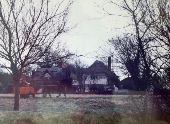
Fishers from the same view, the last time it was visible beyond the foliage, sometime in the 1980s, with pony and trap in the foreground. Photographed by my late brother Jules William Fiske-Harrison, 1969-1988, who is buried in Layer-de-la-Haye church
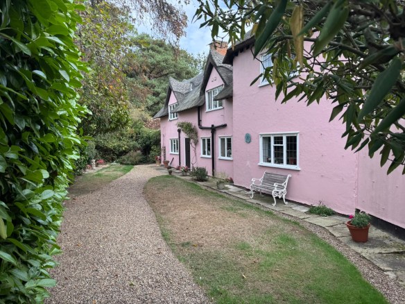
The front of Fishers as is visible today
‘Fishers’, Malting Green, Layer de la Haye: The History Of The House On The Heath
There is an amateur history of the house that became known as ‘Fishers’, published by the Layer-de-la-Haye Women’s Institute in 1965, which says that the house began as a woodman’s cottage in about 1550. However, the carpentry appears far older – even perhaps centuries (just) older than that.
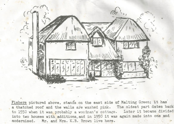
From the publication produced by the Layer-de-la-Haye Women’s Institute in 1965 for the Golden Jubilee
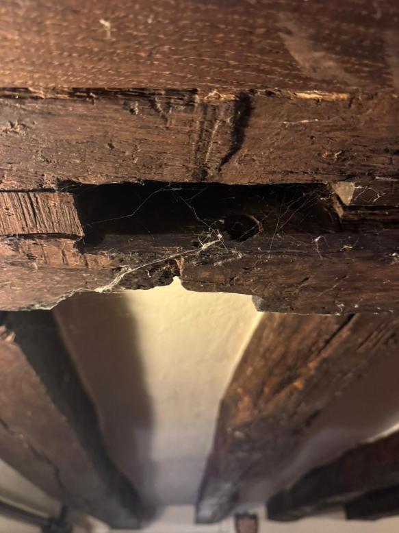
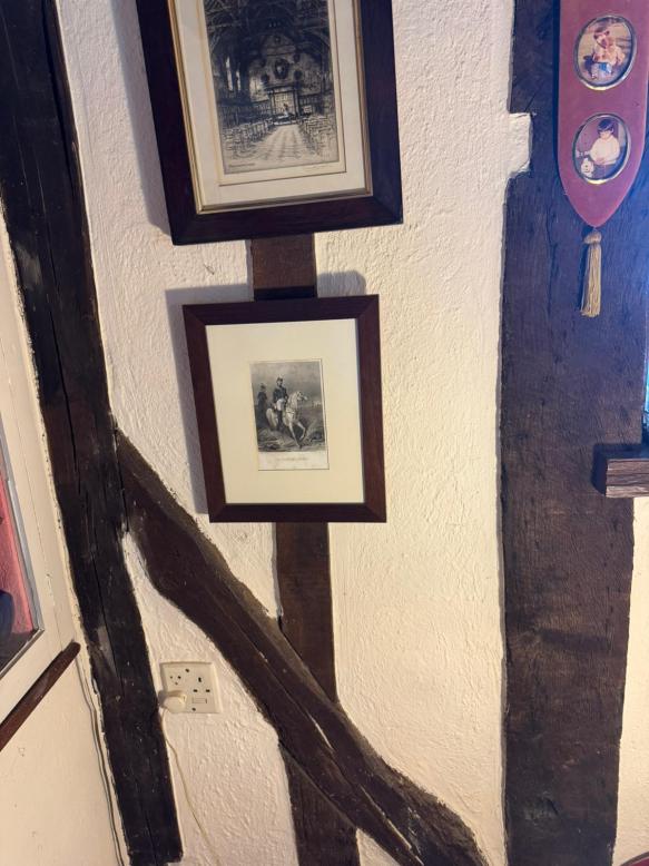
What survives inside the later house is an ancient timber building: a smaller framed structure, originally perhaps one or two rooms below and one above, no more than twenty-two feet by twelve on the ground. It was subsequently doubled into two cottages, side-by-side and eventually absorbed into the present house.
The oak frame of the original house survives with remarkable completeness. The ceiling is carried on sixteen massive, irregular joists, reduced at their ends to simple central tenons and pegged into a great binding beam. Two former external walls retain long diagonal braces trenched into the uprights; one passing brace runs for a dozen feet through successive members of the frame. The principal timbers were assembled green and have since split spectacularly as they dried around their fixed joints, some seasoning fissures now exceeding an inch in width. There are redundant mortices where earlier braces or other members have disappeared, while later generations have reinforced the old frame rather than replacing it.
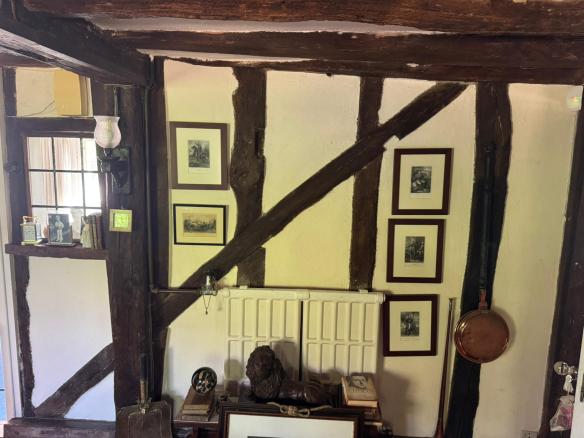
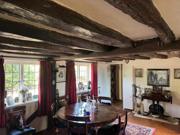
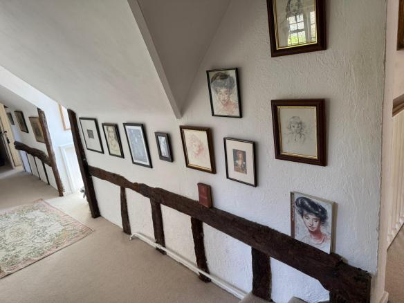
The closest Essex parallels for that combination of central-tenoned flooring and trenched or passing wall bracing lie chiefly in the fourteenth and fifteenth centuries. There are examples of the underlying carpentry vocabulary by about 1300, so there is no technological barrier to an early date; what pulls the balance later is simply the distribution of the closest dated analogues.
My present working probabilities would put its earliest origin mid-14th century – perhaps the narrow interval between the Battle of Crécy in 1346 and the arrival of the Black Death in 1348–49, continuing with high possibility through the Battle of Agincourt and the rest of the Hundred Years’ War, with probability declining to near zero as we reach the early Tudor period.
That early possibility becomes rather less extravagant once one stops assuming that the first inhabitants were as poor as the agricultural labourers who occupied the building five centuries later. The later history of the house known as Fishers on its acre of land associates it with Potash Field, roughly nine further acres, separate from the vast “waste-land” of woods and pasture and the great farms around it. That cannot simply be projected backwards into the fourteenth century; but neither need the medieval occupant be imagined as a peasant. A woodman, forester or other rural specialist with an acrage in the double figures is perfectly compatible with a small house, especially one who may have returned from service to the King against the French with some pay and loot, the soldier’s due at that time.
So is the carpentry. The trees were selected economically — crooked trunks, knots and natural deviations were accepted — but there is an enormous quantity of oak in the floor and the joists are closely set. The work more than competent. It is heavily built, technically assured, parsimonious but definitely not makeshift.
Before The House
The village is is much older than the house. A church certainly existed by 1128, and part of the present chancel is twelfth-century. By 1189 Richard I was confirming the church of Layer and its revenues to the Augustinian Priory of St Botolph in Colchester. For centuries the parish was supplied ecclesiastically from the great religious houses of Colchester, first St John’s Abbey and then St Botolph’s Priory. (Source: Layer Churches)
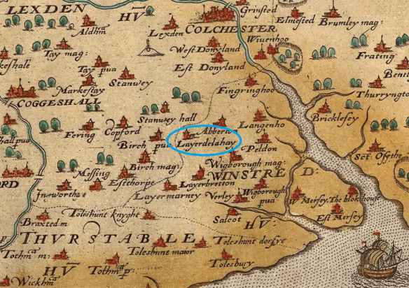
Christopher Saxton’s 1576, Map of Essex
It was a minute and dispersed rural community. The Domesday Book combines the three Layers that exist today into one. The word itself derives from the Anglo-Saxon word legra, meaning look out, and from the tower of church, which is built on the highest point of the village, one can see the coastline five miles east, where the Vikings regularly raided, and, according to Burke’s, my own family’s Fiske ancestors arrived at the Battle of Maldon in 991 A.D. ten miles further southward down the coast.
Layer-de-la-Haye remained very small. The 1327 lay subsidy raised only 19s. 7d. from the village, whereas the assessment in 1524 was £8 18s. 1d., more than nine times as much. (Source: ERA) I would picture the Layer of the 1340s not as a modern village in miniature but as perhaps a dozen scattered households: manor, church, mill, small holdings and cottages dispersed across forest and woods, fields and heath.
The church itself gives some sense of what happened next. Historic England dates the surviving chancel principally to the twelfth century, but the nave and west tower to the fourteenth. Local church history records the reason: after the Black Death the church became utterly derelict, and the canons of St Botolph’s rebuilt the nave and tower after the recovery from that catasrpohe after the 1350s. (Source:Historic England) The old chancel is therefore the physical residue of the pre-plague church; the larger building which one sees today began to rise out of a near apocalypse that killed half of England and an even higher percentage of this region.
That is the landscape into which the earliest version of this house fits. If it was raised in the late 1340s, then its first occupants watched a community collapse around them within a year or two. If it was built after 1350, it belongs instead to the reconstruction: a countryside with land but too few people, changing tenures, higher wages and opportunities for survivors. Either is historically plausible.
A Plantagenet House
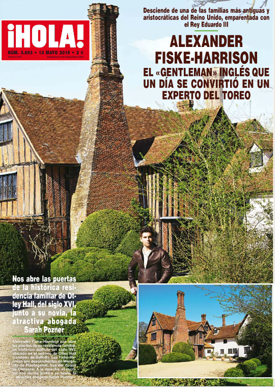
An article from ¡Hola! magazine in 2014 about my visit to the house of my cousins, the Gosnolds, and their house in Suffolk. Martha’s Vineyard in the USA is named after Martha Gosnold, and they are descendants of Margaret Plantagenet, last born of that name, Countess of Salisbury and richest woman in England who was executed for her religion by her cousin the King Henry VIII. Her brother was a cardinal and she was made a martyr of the Catholic Church.
Another probable period is the mid-fifteenth century. In that case ‘Fishers’ arose while Henry VI was king, perhaps at almost exactly the time he founded Eton, my old school, in 1440.
‘Fishers’ would still have stood far outside anything we would recognise as the centre of a village. Layer was not laid out around streets. It was a scattering of holdings separated by cultivated land, woodland and extensive “waste”.
Nor should the house be imagined in its present proportions. The oldest coherent structural cell appears to have been small. Later work extended it longitudinally; another framed section was eventually attached, and the building became the pair of cottages recorded in the nineteenth and twentieth centuries. The original roof has gone and the roof-line was later raised, depriving us of some of the most diagnostic medieval carpentry.
Layer Heath
For the later history we cease having to reason principally from carpentry, because the maps arrive.
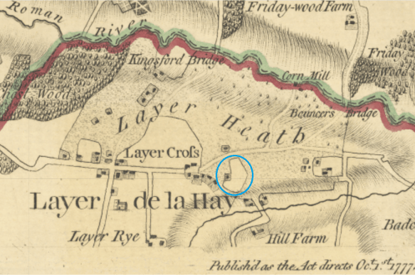
The house that became ‘Fishers’ and the enclosure that became ‘Potash Field’, circled in blue, on a detail of Chapman & André, A Map of the County of Essex (1777).
John Chapman and Peter André’s A Map of the County of Essex from an Actual Survey taken in 1772, 1773 and 1774, published in 1777, was exceptionally detailed for its date: roughly two inches to the mile, showing individual rural houses, roads and many tracks. Fishers is already there. (Source: Essex Archives Online.)
The setting is much more revealing than the building symbol. What is now Malting Green formed part of the enormous Layer Heath, an irregular expanse which the Colchester Historic Environment Record calculates at about 300 acres in 1777. (Source Colchester Heritage Explorer.) Fishers and the field stood as an island squarely within its boundaries. There was no road or even track close to the property. The house related directly to the heath.
That landscape was already changing rapidly by the end of the century. The 1799 Ordnance Surveyor’s Drawing of Witham, OSD 140-2, the manuscript survey from which the later one-inch mapping was produced, shows new fields biting into the heath and Potash Field itself divided more intricately. (Source: Wikidata.)
Two Cottages
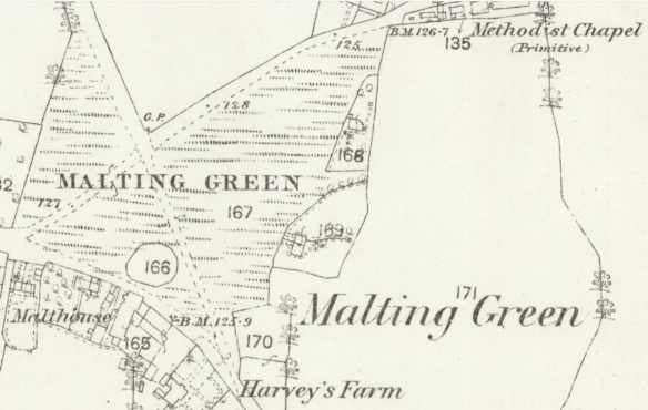
The two semi-detached cottages later called ‘Fishers’ are marked as lot 169, which is clearly divided within the building and outside, with two entrances onto the green to the west, and footpaths running around the house, rejoining either side of a fence to the east of the house which incorporates both the well and out door facilities.
By the first large-scale Ordnance Survey the building can be read almost as an archaeological plan. Essex County Series, First Edition, sheet XXXVI.7, surveyed 1874 and published about 1876, shows the divided cottages, the well, the small service building behind them, and a network of narrow paths. Two entrances lead from Malting Green, one to either side of the divided building; paths pass around the cottages, meet at the well and continue towards the little ‘outbuilding’ – or privy – and Potash Field. A physical boundary — fence, hedge or similar — also appears to have separated parts of the domestic plot.
Most remarkably, much of this minor landscape survives. The well is still there, complete with its later cast-iron hand pump. The gazebo occupying the position of the nineteenth-century outbuilding is still there, although rebuilt but still with tell tale hole in the middle of its floor. An old cesspit survives close by beneath a cast-iron cover which now serves the pool house for the swimming pool my parents built in the 1970s.
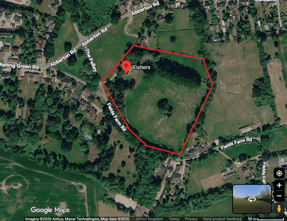
Fishers on Google Maps
Walter Fisher
In 1921 the great Berechurch Hall manorial estate was broken up. Essex Record Office preserves the enormous sale catalogue: the estate ran to thousands of acres across Berechurch and Layer-de-la-Haye, including farms, cottages and the Manor of Blind Knights. (Sourcew: Cat UK.) Among the properties sold were the pair of tiny cottages which would later become known as Fishers.
The sale particulars give the northern cottage to Walter Fisher as occupant and the southern to Joseph Cooke. The 1921 census supplies the human scale. Fisher, a ploughman aged fifty, lived there with his wife Ada, fifty-one, and six children. Cooke, an agricultural labourer aged fifty-one, lived next door with his wife Elizabeth, forty-eight, and two children.
The entire pair of cottages measured only about 36 feet by 12 feet on the ground, roughly 432 square feet per floor and about 864 square feet over both floors together. Each cottage consisted essentially of a tiny kitchen, living room and one bedroom. Twelve people occupied the pair. Eight of them — Walter, Ada and six children — had only one bedroom between them. Water still came from the well outside; sanitation remained outside the house.
What makes those facts vivid is the date. In April 1919, while Parliament was debating the housing crisis which produced the Housing, Town Planning, &c. Act 1919, MPs cited an Oxfordshire survey of about 1,000 rural cottages, more than seventy of which contained more than a married couple in a single bedroom. “Very often,” the House was told, there were five and six children living in a bedroom; one recorded family had teenage boys and girls sleeping in the same room as their parents. “That sort of thing cannot be tolerated any longer.” (Source: Hansard.)
Later that year the Government stated its minimum proper family accommodation as one living room and three bedrooms: one for the parents, one for boys and one for girls. (Source: Parliament API.) At the same time, Walter Fisher was living with his wife and six children in a cottage with one bedroom.
The building may therefore have been not only the oldest domestic structure in Layer de la Haye, but the poorest: a house whose extreme economy of space survived from the medieval rural world into the age of motor cars, telephones and the first council housing. 1921 was the year F. Scott Fitzgerlad set the opulence of The Great Gastby and Evelyn Waugh that of Bridehead Revisited.
The building’s present name comes from that period. In the 1921 sale it is simply a pair of cottages. Later deeds identify the property by its former occupiers, W. Fisher and J. Cook. By 1950 the name has hardened: the probate record for Katharine Pennington Leeston-Smith gives her address simply as Fishers, Layer-de-la-Haye. The name is therefore not ancient. It is Walter Fisher fossilised in the postal address.
From Labourers To Gentry
The social transition after 1921 is abrupt.
The cottages were purchased from the Berechurch Hall manorial estate by the Thorburn family of Berkshire who had made their fortune in British India and intermarried with the Leeston-Smith family who own the 19th century Grade II* listed house across the road from Fishers.
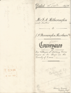
In 1939 they were transferred within the family to their in-laws, the Leeston-Smiths. The conveyance still describes the cottages as “recently in the occupation of W. Fisher and J. Cook”: both labouring households had therefore gone by then.
In 1941 the two elderly Leeston-Smith ladies formalised their interests in the property between themselves. Walter Fisher died in the Colchester district that same year.
The physical transformation of the cottages belongs to this period. Two elderly ladies accustomed to the substantial house across the Green were not likely to move into a pair of labourers’ cottages while continuing to carry water from a pump and use an earth privy in the garden. The most economical explanation is that the first serious plumbing and sanitation were installed around 1939–41 and the conversion of two labourers’ households into one genteel residence. The old well and out-house that remain today were simply left behind.
Muriel Margaret Leeston-Smith died in 1946. Katharine Pennington Leeston-Smith died at Fishers on 1 May 1950; her probate estate was £13,968 14s. 4d., substantial money at the time.(See footnote [1] below.) Her probate address proves that by then the house had acquired the name it still bears.
Her brother-in-law, Colonel John Frederick Pennington Thorburn, M.C., was left the house in her will, and moved in with his wife.(See footnote [2] below.) His younger brother Brigadier Thorburn lived across the road at Malting Green House and that was the period during which the greatest changes were effected on the house, not only unifying it, but going on to more than double the newly single house’s size while preserving and maintaining the ancient structure within, constructing a tennis court and an automobile garage that stands to this day accessible across the middle of what is now Malting Green.
Colonel Thorburn died in 1958, and the house was purchased by an even more senior army officer and war hero, Brigadier Ord Henderson Tidbury, M.C., who did works of his own, including building at second double doored garage opening on to the green from the other side of the house. He died in 1961.
From him it went to Lieutenant-Commander Kenneth Binfield Brown, D.S.C, of the Royal Navy, and later a director of Tate & Lyle, who completed the modern additions, building a large car port as well. and from him to his widow.
(During that period Malting Green House passed from the Thorburn family to that stockbroker, partner of Cazenove & Co, and descendant of the author of King Solomon’s Mines, Rae Haggard Lister, who lives there to this day.)
1972
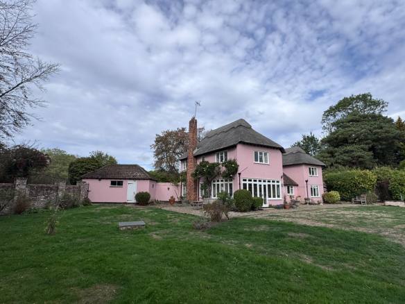
My parents bought Fishers from Mrs Brown in 1972, together with over half of Potash Field which she divided with a fence, accessing her portion via the historic access over Malting Green in order to tend her herd of a dozen or more Holstein Friesian cattle. Meanwhile our larger portion, accessed via a gateway on Fields Farm Road, variously had sheep, horses, grew corn brielfly, then hay and then wild flowers. They built a swimming pool but other changes have been cosmetic and negligible.
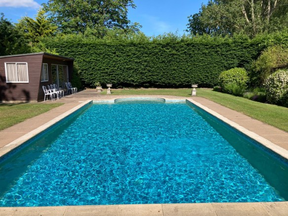
By then Fishers was recognisably a comfortable country house. There is a symmetry in the family which eventually settled here. My father, Clive Fiske Harrison, was born in Colchester, was educated at nearby Felsted School and Cambridge University and, having moved to London for work, bought Fishers in 1972 to be close to his parents at Aldouron House on Mersea Island and his siblings in nearby Peldon, Abberton and Fingringhoe.
The following year he left Panmure Gordon where he worked under Ian Cameron, father of the future Prime Minister David, and founded the stockbroking firm which eventually become Fiske plc.
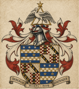 His coat of arms at the College of Heralds is styled Harrison of Layer-de-la-Haye and quarters by descent the arms of the East Anglian Fiske family. The Fiskes are deeply rooted in the eastern counties, noted as the landowners under the name ‘Fisc’ in Norfolk in the Domesday Book of 1085 at Wood Dalling, and then – with an uninterrupted line of descent, as Lords of the Manor in Stadhaugh, in the Parish of Laxfield in Suffolk by the 1200s as Ffyske.
Meanwhile, this East Anglian house has passed through an extraordinary social arc. It may have begun under the Plantagenets as the compact holding of a woodman on the edge of an immense heath. It survived plague, enclosure and the disappearance of neighbouring dwellings. It became two cottages and, as late as 1921, contained twelve people in conditions Parliament had just declared intolerable. Within twenty years it crossed almost instantaneously from agricultural labourers to landed gentry. Since 1972 it has remained one family home.
The great irony is that the later house concealed the earlier one almost too successfully. Fishers was overlooked when Layer-de-la-Haye’s historic buildings were surveyed for listing in 1982. Yet inside it the medieval building remains: crooked green oak, great pegged joists, passing braces, redundant mortices and all. The later centuries did not destroy it. They simply accumulated around it.
A. R. Fiske-Harrison, Esq., M.A. (Oxon.), M.Sc. (Lond.)
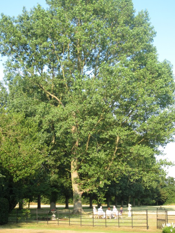
My parents and family and friends under one of the great poplar trees in the summer of 2016
Footnotes
[1] For comparison, our other residence, the upper and lower ground floors and garden of 114, Eaton Square in Belgravia, London, S.W.1., sold for £14,000 at that time, although the Duke of Westminster only sold leases, not freeholds. When it was a house it had been that of Sir George Smyth Baden- Powell, brother of the founder of the Boy Scouts. When I grew up there, our upstairs neighbour was Damian Aspinall the son of the great conservationist, gambler and friend of Lord Lucan, John Aspinall, along with his two daughters Tansey and Freya. I had no idea at the time that my cousin-by-marriage’s aunt, Min Musker, had been married to John Aspinall.
[2] Colonel Thorburn’s wife was born Dorothy Melville de Chair, whose first cousin was mother to the present wife of Jacob Rees-Mogg, M.P., who was so often a guest at lunch in the old boardroom of Fiske & Co, incorporating Bragg, Stockdale, Hall & Co (founded in 1824, and thus the oldest independent stockbroking firm in London), when my father was still chairman in the offices at Salisbury House in the City.

